Tributary Tuesday: Canisteo River (Hornell, Ny.)
In the late 1700s, settlers arrived in the Canisteo watershed and cut down nearly 70 percent of the trees in the region.
In the late 1700s, European and American settlers arrived in the Canisteo watershed in southwestern New York. They cut down nearly 70 percent of the trees in the region and began farming. The Canisteo watershed remained an important region for the nineteenth century early timber industry, but excessive logging and ensuing development drained nearly all of the river’s wetlands.
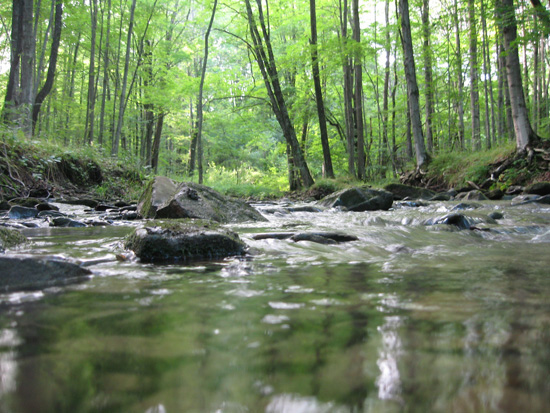
(Image courtesy mediafury/Flickr)
Today, many hillsides have been reforested, creating a colorful view during peak fall foliage. The few marshes that dot the valley today serve as reminders of the Canisteo of the early 18th century. The river’s beauty still entertains nature photographers, kayakers, whitewater rafters, and hikers alike.
The 61-mile long tributary of the Tioga River gets its name from a Native American word for “head of water,” an appropriate name for this Susquehanna “headwaters” stream. Rising in the hills of northern Allegany County, the Canisteo flows through a valley of steep hillsides and farmland before joining the Tioga just above the New York/Pennsylvania state line.
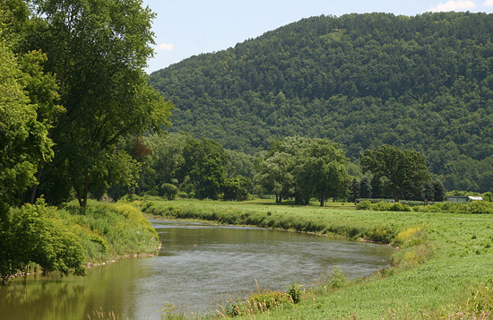
(Image courtesy Wikimedia Commons)
More from the Canisteo River:
- Golfers can enjoy breathtaking views of the river valley at Pinnacle State Park and Golf Course.
- Looking for a rustic outdoors experience? There are no designated trails at Canacadea State Forest, near Hornell, Greenwood State Forest, near Canisteo, or Cameron State Forest. Forge your own path.
- Hunters and trappers frequent the 126-acre Helmer Creek Fish and Wildlife Management Area near Rathbone.
Comments
Having raced canoes on the Cohocton, the Canisteo, Tioga, Chemung, and Susquehanna years ago, without realizing that all of these rivers ended up in the same place, I think its very interesting now, years later, to see the way they were all connected. We raced flatwater canoes all over upstate NY back in the 70's, beginning w/ the Cohocton -- starting somewhere downstream from the actual village of Cohocton. We also raced on the Canisteo, and Tioga, not so much on the Chemung, and both branches of the Susquehanna, all over the many creeks and rivers around Cortland and everwhere in between that winter melt made possible -- during the still freezing months od February and March.. Some of these narrow feeder creeks were so narrow that passing other canoes was nearly impossible, running thru cow pastures and farmlands, eventually merging with a real river. Interestingly, they all ended up being part of the Eastern branch of the Susqhehanna.
The Chemung river high water flood marks in Corning NY are a frightening reminder of what can happen when a prolonged heavy rain, such as a coastal hurricane, hits the watershed of those 4 or five rivers, with the interesting Indian names, that converge just west of that city.
Thank you!
Your comment has been received. Before it can be published, the comment will be reviewed by our team to ensure it adheres with our rules of engagement.
Back to recent stories