Maintain Healthy Watersheds Goal Implementation Team (GIT 4)
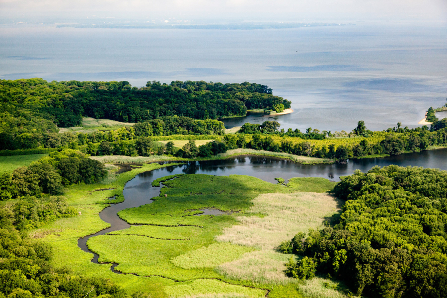
The Maintain Healthy Watersheds Goal Implementation Team works to keep local watersheds healthy across a range of landscapes, bringing attention to the challenge of protecting streams and watersheds that are healthy today and restoring waters if they become degraded.
Meetings
No upcoming meetings.
CANCELED: Maintain Healthy Watersheds GIT Meeting - December 2025
CANCELED: Maintain Healthy Watersheds GIT Meeting - October 2025
Maintain Healthy Watersheds GIT Meeting - September 2025
About
The Healthy Watersheds Goal Implementation Team (HWGIT) works to maintain local watersheds at optimal health across a range of landscape contexts. The HWGIT intends to bring attention to the challenge of protecting streams and watersheds that are healthy today, as a programmatic complement to the "impaired waters" approach that focuses on restoring waters if they become degraded. Healthy watersheds sustain local social, economic and environmental benefits at optimal levels and contribute to the achievement of Chesapeake Bay Program goals for the tidal Chesapeake Bay and tributaries. The optimal levels at which such benefits are sustainable will depend upon the landscape context of the watershed.
The principle rationale for the Healthy Watersheds goal is that balanced strategies for natural resource restoration, protection, investment and management are necessary to achieve a sustainably restored Chesapeake Bay. Conserving natural resources is a more cost-effective strategy to achieve Chesapeake Bay water quality goals. In addition, maintaining healthy local watersheds is more meaningful to communities since the majority of citizens are more likely to be concerned about the health of their local streams than the Chesapeake Bay.
Strategies
The HWGIT has identified four strategies to ensure the long-term conservation of healthy watersheds:
- Tracking the health of watersheds and our effectiveness in protecting them.
- Strengthening local commitment and capacity to protect healthy watersheds.
- Improving protection of state-identified healthy watersheds under federal programs and federal agency decision-making.
- Supporting state-based efforts to improve assessment and protection of healthy watersheds.
An updated map of State-Identified Healthy Waters and Watersheds and progress toward the Maintain Healthy Watersheds goal can be viewed at ChesapeakeProgress.
Projects
Chesapeake Healthy Watersheds Assessment 2.0
CompleteBuilt on the foundation of CHWA 1.0 and the Maryland Healthy Watersheds Assessment, this new application can be used to investigate watershed conditions and vulnerabilities within state-identified healthy watersheds and throughout the Chesapeake Bay watershed.
Maryland Healthy Watershed Assessment
CompleteThe Maryland Healthy Watershed Assessment establishes a framework of watershed health and vulnerability metrics for assessing Maryland waters and watersheds.
Chesapeake Healthy Watersheds Assessment 1.0
CompleteThe Chesapeake Healthy Watersheds Assessment helps partners identify "signals of change" in vulnerable or resilient healthy waters and watersheds.
Map of State-Identified Currently Healthy Waters and Watersheds (2017)
CompleteThe Healthy Watersheds Outcome in the 2014 Chesapeake Bay Watershed Agreement states that 100% of these waters and watersheds will remain healthy.
Conservation Land-Use Policy Toolkit
CompleteThis toolkit provides local governments in the Chesapeake Bay watershed with information about land-use policy tools they can use to slow the conversion of farmland, forestland and wetlands.
Publications
2024 Healthy Watersheds Outcome Review Summary
Publication date:This document was presented to the Management Board as part of the 2024 Strategy Review System cycle.
View document [PDF, 233.2 KB] 2024 Healthy Watersheds Outcome Review Summary
2024 Healthy Watersheds Presentation
Publication date:This document was presented to the Management Board as part of the 2024 Strategy Review System cycle.
View document [PDF, 1.3 MB] 2024 Healthy Watersheds Presentation
2021 Healthy Watersheds Logic & Action Plan
Publication date:This work plan was developed as part of the 2019-2021 Strategy Review System cycle.
View document [PDF, 311.4 KB] 2021 Healthy Watersheds Logic & Action Plan
2021 Healthy Watersheds Narrative Analysis
Publication date:This document was presented to the Management Board as part of the 2019-2021 Strategy Review System cycle.
View document [PDF, 318.9 KB] 2021 Healthy Watersheds Narrative Analysis
2021 Healthy Watersheds Presentation
Publication date:This document was presented to the Management Board as part of the 2019-2021 Strategy Review System cycle.
View document [PDF, 2.7 MB] 2021 Healthy Watersheds Presentation
Our Watershed Agreement Goals & Outcomes
Healthy Landscapes Goal
Our Members
- Jeff Lerner (Chair)
U.S. Environmental Protection Agency (EPA) lerner.jeffrey@epa.gov - Deborah Herr Cornwell (Vice Chair)
Maryland Department of Planning deborah.herrcornwell@maryland.gov - Peter Claggett (Coordinator)
U.S. Geological Survey (USGS) pclaggett@usgs.gov - Scott Heidel
Pennsylvania Department of Environmental Protection scheidel@pa.gov - Shane Kleiner
Pennsylvania Department of Environmental Protection shkleiner@pa.gov - Ashley Hullinger
Pennsylvania Department of Environmental Protection ahullinger@pa.gov - Mindy Neil
West Virginia Department of Environmental Protection Mindy.S.Neil@wv.gov - Holly Walker
Delaware Department of Natural Resources and Environmental Control Holly.Walker@delaware.gov - Gabriella Vailati
Delaware Department of Natural Resources and Environmental Control gabriella.vailati@delaware.gov - Stephen Williams
Delaware Department of Natural Resources and Environmental Control stephen.williams@delaware.gov - Cassandra Davis
New York State Department of Environmental Conservation cassandra.davis@dec.ny.gov - Lauren Townley
New York State Department of Environmental Conservation lauren.townley@dec.ny.gov - Angel Valdez
Maryland Department of the Environment angel.valdez@maryland.gov - Todd Janeski
Virginia Department of Conservation and Recreation tvjaneski@vcu.edu - Lorena Kowalewski
District of Columbia Department of Energy & Environment lorena.kowalewski1@dc.gov