A trail of caves, karst and other wonders
Beginning some 500 million years ago, as the geologic layers underlying Virginia’s Ridge and Valley Province started forming under water, a collection of decomposed sea creatures and their shells fell to the ocean floor and hardened under subsequent layers of sediment.
This layer of marine ruins is known as limestone, the unassuming grayish-white rock you might remember from geology lectures. Later, when tectonic movements produced the above-ground ridges and valleys we see today, the limestone layer remained and still makes up a considerable part of the province.
But there’s a unique characteristic of limestone that’s important to this history. Unlike other rocks, limestone dissolves easily when it interacts with acid. The level of acid naturally found in rainwater, for example, is enough to do the job. As rain hits the ground and seeps into the earth, it eventually finds the limestone and breaks it down over long periods of time, leaving hollow sections we know as caves.
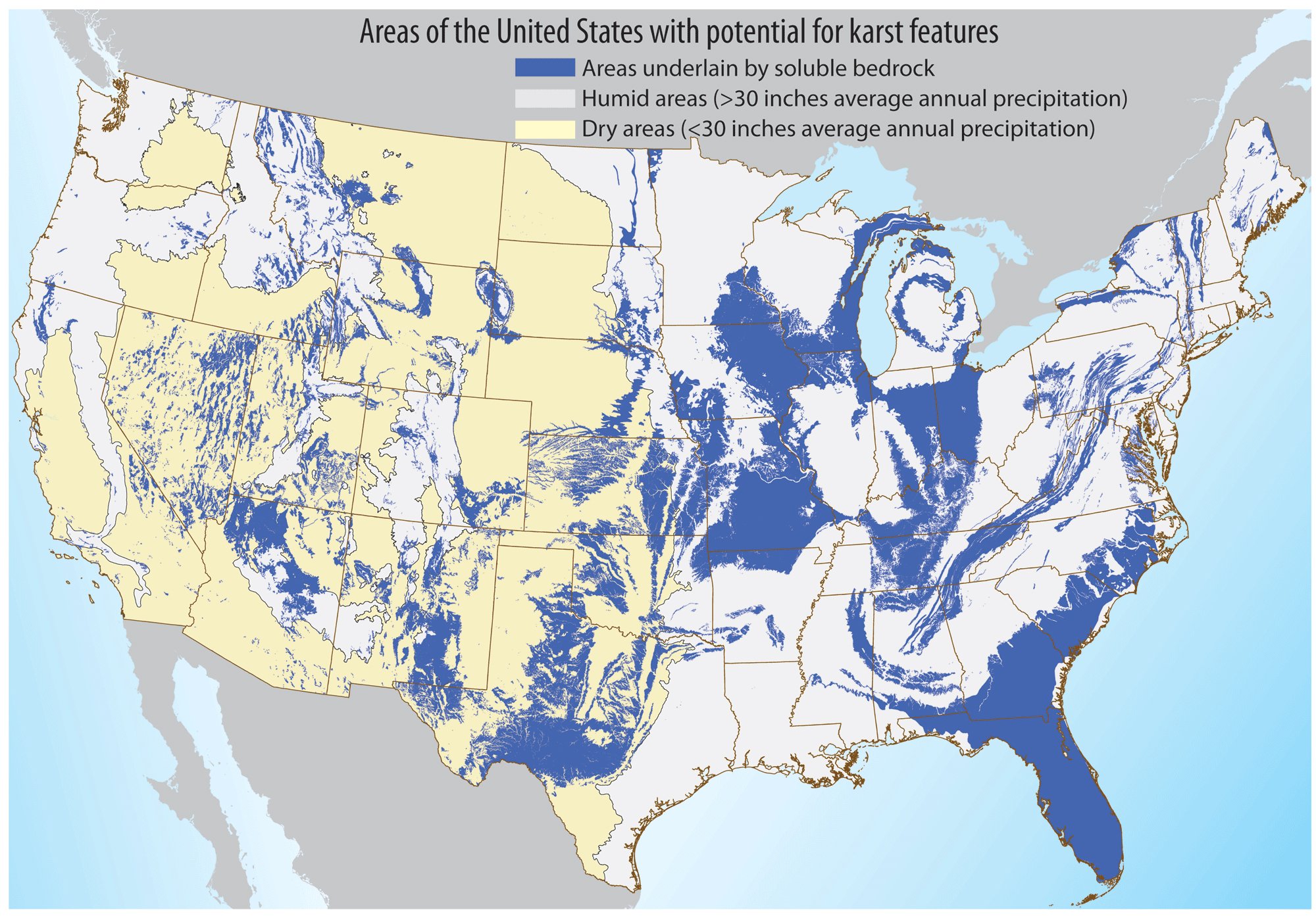
When water dissolves calcium carbonate-rich rock such as limestone, it forms a landscape called karst. Caves are typical features of karst regions, but so are caverns, sinkholes, streams and springs, which are also formed when these types of rock are dissolved. In the Ridge and Valley Province, it’s an abundance of limestone and a bit of dolomite (another calcium carbonate-rich rock) that make the area rich in karst, and therefore rich in caves.
Virginia's Cave and Karst Trail
Virginia itself is a hotbed of caves, with over 4,400 documented in the Commonwealth, but the Ridge and Valley Province is where you’ll find the most cave and karst formations.
The Virginia Cave and Karst Trail is found mostly within this region. It was created by the Virginia Cave Board to educate people about these sensitive environments and to promote their protection. There are more than a dozen stops on the trail, including “show caves” which are open to the public, springs, waterfalls and an array of fascinating karst formations.
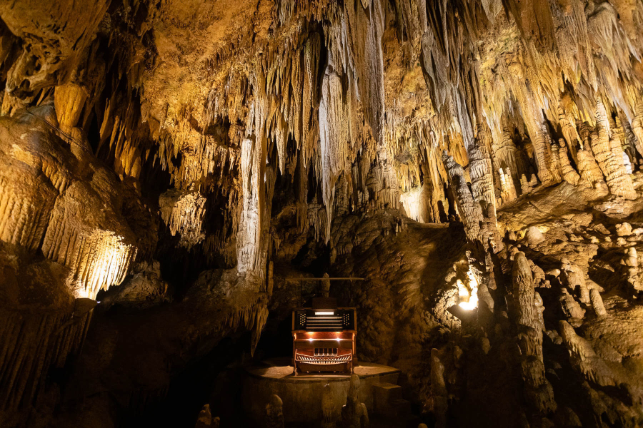
At the northern part of the trail is Luray Caverns, the largest cavern in the eastern United States, boasting cathedral-sized rooms with ceilings 10-stories high. In one chamber you’ll find the one-of-a-kind Stalacpipe Organ, an instrument that is hooked up to the caverns’ stalactites (the icicle looking features that hang from a cave ceiling) so that it can play notes off the different sized stalactites.
Stop about midway through the trail in Alleghany County and you’ll find the Falling Spring Falls Overlook, a breathtaking 80-foot waterfall that is fed by a thermal spring. The waterfall is the largest in Virginia, but people are not permitted to hike it due to safety issues and protection of the fall itself. Follow signage and be sure to view responsibly.
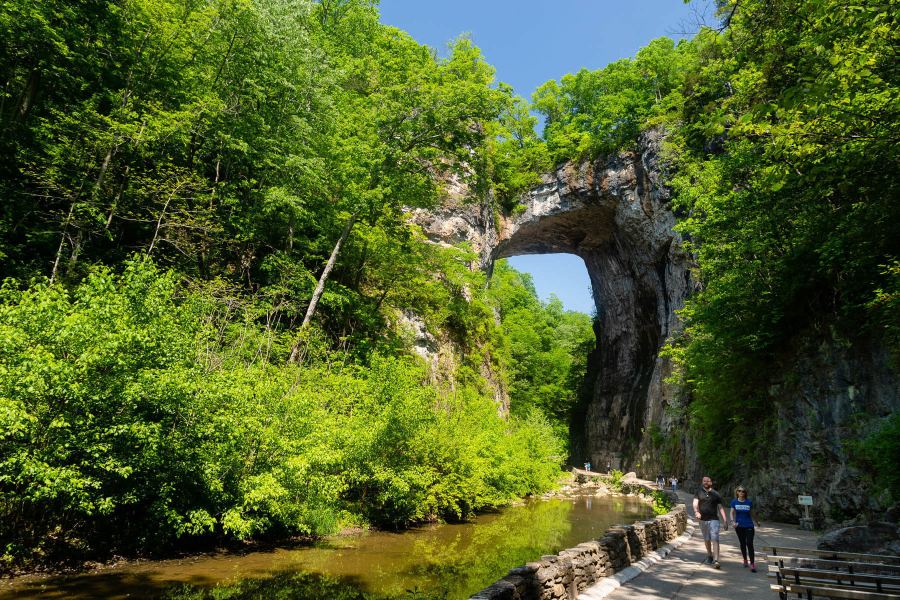
Another popular landmark on the trail is the Natural Bridge in Rockbridge County, a naturally-formed bridge that is more than 850 feet long and as high up as a 10-story building. This bridge is made of karst, and was formed when a limestone ridge was carved out over thousands of years.
Plenty of other wonders can be found along the Virginia Cave and Karst Trail, but what might interest you further is how the water we drink, swim in and harvest seafood from, is connected to the water traveling through these subterranean landmarks.
How caves connect to the rivers of the watershed
The same water that once formed caves and karst structures in Virginia continues flowing underground, and often connects to various above ground rivers and streams that drain into the Chesapeake Bay.
Surface water will often connect to underground aquifers, which are opening in rocks where water can collect or pass through. But with karst aquifers, which are created from dissolved limestones and other easily dissolvable rock, the water may enter much more quickly through sinkholes and other openings. This direct connection to the surface causes karst areas to be extremely vulnerable to groundwater contamination from above ground sources.
Polluted runoff from factories, developed areas, farms and even carbon emissions can taint the water that enters caves and karst aquifers. Once underground, it can follow unexpected paths very quickly, while carrying contaminants and pathogens from the surface.
Municipalities, homeowners with well water and water-dependent businesses and farming operations all pull from water that interacts with what is traveling through karst aquifers. This water also impacts the rivers and streams that the fish we catch and eat swim in.
The same ways we protect above ground waterways will also protect water running underground. Conservation practices, such as streamside forest buffers, stormwater management and wetland conservation all benefit underground water. Better understanding on how water travels through caves and karst aquifers will also help organizations prioritize areas that have the greatest impact on the water that people and wildlife rely on.
The sensitivity of underground water systems shouldn’t stop you from exploring Virginia’s caves and karst formation, but if you find yourself among these subterranean wonders, just remember that they are as important to the overall ecosystem as your local stream or backyard.
Comments
There are no comments.
Thank you!
Your comment has been received. Before it can be published, the comment will be reviewed by our team to ensure it adheres with our rules of engagement.
Back to recent stories