On National Take a Hike Day, Pennsylvania can show you where to go
Pennsylvania Department of Conservation and Natural Resources recognizes the crème de la crème of hiking trails

Since 2014, the Pennsylvania Department of Conservation and Natural Resources has encouraged individuals and organizations to nominate exceptional trails to be formally recognized. The designation of Pennsylvania’s Trail of the Year is overseen by the volunteer-led Pennsylvania Trails Advisory Committee.
The award was created to raise public awareness of the roughly 11,000 to 14,000 miles of trails available for public recreation.
While the nomination criteria may seem simple — trails must be land-based and open to the public — there is one catch: The nominator must submit a narrative statement written by the organization responsible for managing the trail and collect five to 10 letters of support from recreators, volunteers, officials, nonprofits or businesses.
So, when you’re looking for some trails to explore in honor of this year’s National Take a Hike Day, look no further than these exceptional routes found throughout Pennsylvania. Here are a few winners located within the Commonwealth’s portion of the Chesapeake Bay watershed.
Heritage Rail Trail - York County
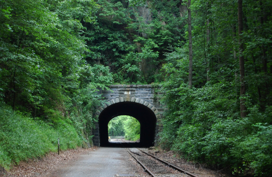
The Heritage Rail Trail had the distinction of being named the second Trail of the Year. Running more than 21 miles from downtown York to the Maryland state line, it connects with the Torrey C. Brown Trail in Maryland, creating a 43-mile continuous route. The trail is maintained by the York County Department of Parks and Recreation and includes seven railroad structures and an operating tourism train where the former Northern Central Railroad once operated.
One of these structures is the Hanover Junction telegraph office, which served as a major communications hub between Gettysburg and Washington, D.C., during the Civil War. Abraham Lincoln even changed trains at this spot while traveling to deliver the Gettysburg Address. Another significant feature is the Howard Tunnel, the oldest railroad tunnel in the country. Built in 1837, the Union Army once placed cannons on top of the 370-foot stone arch to defend against Confederate attacks.
Today, the crushed-stone trail is popular among bikers, hikers, cross-country skiers and snowshoers.

Standing Stone Trail - Fulton, Huntingdon and Mifflin counties
The Standing Stone Trail winds 84 miles through three counties, two state parks and one natural area in southcentral Pennsylvania. Along its path, it ranges from 660 feet to 2,380 feet in elevation. It is part of the Great Eastern Trail, which runs from the Florida–Alabama line to the Finger Lakes in New York. Its name honors the Oneida Nation, who displayed a “standing stone” in each of their villages.
Constructed in the late 1970s, the trail passes a variety of historical and natural landmarks. One such landmark is Vanderbilt’s Folly, an unfinished project started by railroad baron William Vanderbilt in the late 1800s. Hoping to challenge the Pennsylvania Railroad, Vanderbilt attempted to blast tunnels through several mountains and install culverts and bridges in order to build a competing, more southern rail line. The project went bankrupt but ultimately parts of it became what is now the Pennsylvania Turnpike.
Some of the natural wonders you will encounter along the way include Jacks Narrows and the Thousand Steps, which are considered to be outstanding geological features. Jacks Narrows is a deep gorge and water gap, while the Thousand Steps is a manmade formation of steps up the side of Jacks Mountain. Hiking and trail running are permitted along the Standing Stone Trail, and camp sites are also available.

Mid State Trail–Bedford and Tioga counties
The Mid State Trail is Pennsylvania’s longest hiking route, spanning about 330 miles from the Mason-Dixon Line to the New York border. Along the way, it crosses eight state parks and five state forests, earning the title of the wildest footpath in the Commonwealth. Like the Standing Stone Trail, it is part of the Great Eastern Trail. It is also the first trail in the country to use metric distances and elevations — a choice made by its founder, Dr. Tom Thwaites, who hoped the United States would someday adopt the metric system.
Dr. Thwaites, affectionately known as the father of the Mid State Trail, was a professor at Penn State and often took his students hiking. The first section of the trail was developed in 1969 by the Penn State Outing Club. Since then, three more sections have been added, and the entire trail is maintained by the Mid State Trail Association.
The trail cuts through some of Pennsylvania’s most iconic natural landscapes, including Cherry Springs State Park, the first designated International Dark Sky Park in the United States. It also passes through the Pennsylvania Grand Canyon, which stretches for more than 45 miles and drops about 1,500 feet, as well as the Pennsylvania Wilds, an official Conservation Landscape that includes more than 2 million acres — the greatest concentration of public land in the Commonwealth.
D&H Rail Trail–Lackawanna, Susquehanna and Wayne counties
The Delaware & Hudson Rail Trail, commonly referred to as the D&H Rail Trail, stretches 38 miles through northcentral Pennsylvania. The crushed-stone trail is used for hiking, biking, horseback riding, cross-country skiing, snowshoeing and snowmobiling.
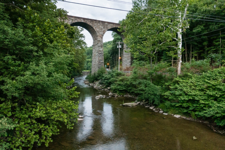
The route follows much of the former Delaware & Hudson Railroad, which carried coal and lumber through northeastern Pennsylvania in the mid-1800s. Today, visitors can follow 18 interpretive signs to learn about the region’s history. Of particular interest is the Starrucca Viaduct, built in 1848 by the New York and Erie Railroad. It is the oldest railroad bridge in Pennsylvania still in operation. Upon its completion, it briefly held the title of the world’s largest stone railway viaduct.
Visit the Pennsylvania Department of Conservation and Natural Resources website to learn about all the trails across the Commonwealth that have received the coveted Trail of the Year designation — and get hiking!
Comments
There are no comments.
Thank you!
Your comment has been received. Before it can be published, the comment will be reviewed by our team to ensure it adheres with our rules of engagement.
Back to recent stories