After unprecedented storms hit New York, communities take a different approach to flood protection
Watershed-focused projects are improving stream health, adding green infrastructure and vacating flood-prone properties
In 2006, a heavy storm hit central New York, breaking records for flooding that had stood since Hurricane Agnes swept up the East Coast 34 years prior. An area along the Susquehanna and Chenango rivers was hit hardest, with rising waters threatening to breach levees and prompting the evacuation of 3,000 people in the city of Binghamton. In a region known for steep hillsides and soils that shed a lot of water, the Susquehanna crested at 33.65 feet in the town of Vestal, and in some areas exceeded what would be considered a 500-year flood.
Just five years later, the remnants of Tropical Storm Lee bore down on the same area, and the Susquehanna’s new high-water mark topped the 2006 record by another foot and a half. Of the homes and businesses severely damaged by Lee, roughly one third were in central New York’s Broome County. Property losses there totaled half a billion dollars.
The storms 2006 and 2011 were a tipping point for efforts to make Broome, neighboring Tioga County and the broader area straddling New York’s border with Pennsylvania more resilient to the risk of floods, which are becoming more frequent and intense because of climate change. In the years since Tropical Storm Lee, a range of flood mitigation efforts have started to take shape, comprising a much different approach than the massive public works projects of decades ago. As opposed to the levees, dams and reservoirs built in the past, the region has turned to multiple small-scale flood prevention projects using a range of more natural techniques.
“There is never going to be one big project that's going to be able to address the flooding,” said Chip McElwee, executive director of the Broome County Soil and Water Conservation District. “Those days are done.”
New York Rising
Following yet another major storm—Hurricane Sandy in 2012—the state of New York responded with a program called the NY Rising Community Reconstruction Program, which served to direct federal funds to hundreds of recovery and resiliency projects at the community level.
The Upper Susquehanna Coalition (USC), for example, received one of several $3 million grants issued by NY Rising to establish the Regional Susquehanna River Initiative, a joint effort between Broome and neighboring Tioga County to identify flood risks and opportunities to enact mitigation efforts.
“We’ve done six different watershed assessments, three in Tioga and three in Broome County, where we’ve been able to basically assess the stream corridor, the riparian areas and the watershed as a whole to look for opportunities for projects,” said Wendy Walsh, watershed coordinator for USC.
The types of projects include restoring wetlands, reconnecting streams with their floodplains, restoring stream corridors, enlarging culverts to better handle large storm flows and pursuing buyouts of properties in harm’s way. The holistic approach is intended to get at the causes of flooding, which often can be found upstream from the flooding itself and crosses jurisdictional lines that have made coordinating projects difficult in the past.
“We might be doing work in Broome County that’ll impact the town of Owego [in Tioga County] positively,” Walsh said. “It’s a more dynamic, watershed approach than just focusing on the river.”
USC has assessed several waterways, including Fuller Hollow Creek, located in the town of Vestal in Broome County. The creek’s naturally winding path was straightened in the 1950s and 60s, at the same time that neighborhoods were built without any structures to retain stormwater.
“That has created a whole slew of spots that have serious erosion and downcutting,” McElwee said.
The creek’s eroded sediment eventually blocked an outflow for treated water at the nearby Binghamton-Johnson City Joint Sewage Treatment Plant. Rather than just removing built-up sediment that would ultimately return, McElwee said the goal was to “take a good hard look at the watershed” and “address some of the sediment issues that would then be impacting the mouth of the creek.”
When it comes to planning for future floods, local officials aren’t only looking out for the biggest storms that flood major rivers. McElwee pointed to a period in 2018 when the Binghamton area was hit by a year’s worth of rain—over 38 inches—in a period of less than five months, from the middle of July to the beginning of December. Two or three inches would fall on soils already saturated from storms in previous weeks, and the water couldn’t soak it in like it normally would on drier ground.
“A lot of ripping and tearing took place in the streams,” McElwee said. “Some of the smaller communities in the uplands were flooded in ways that they had never seen before.”
Floodplain buyouts
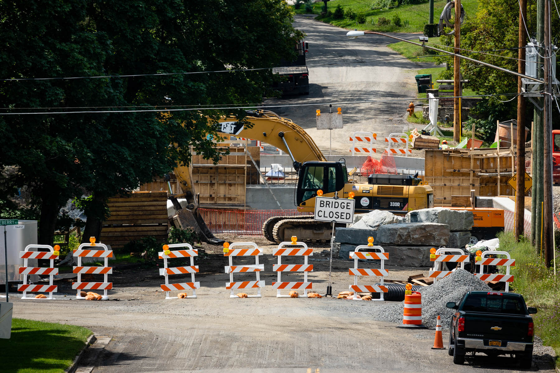
Another project funded through NY Rising is a relocation of the town of Owego’s highway department, which had previously occupied a floodplain where equipment would be repeatedly damaged by floods.
“We decided that it didn't make sense for the town to continually have to replace equipment and stuff,” said Debra Standinger, Owego’s planning and zoning administrator.
In the years after the flooding in 2011, the highway department had been operating out of the town hall garage and using office space there to get above flood elevation. In 2019, construction began on a new facility next door to the town hall that will be shared with other government services—out of a floodplain and equipped with standby power.
Even before this project broke ground, Owego began pursuing buyouts of private property, starting after the 2006 flood.
“We had initially had probably 20 people that were eligible,” Standinger said. “And of the 20, I think we ended up with five that wanted to go ahead with it.”
Interest in the buyout program increased greatly, however, in 2011. Standinger recalled that the first day her office was open after Tropical Storm Lee, residents were asking to be placed on the buyout list. “We did have people drop off,” said Standinger, who pointed out that it takes roughly three years after a flood event for a buyout to be finalized. “People can’t just be in limbo for three years.”
Despite the wait, since 2006, Standinger said Owego has been able to buy out nearly 40 properties.
A more livable future
A buyout restricts the construction of permanent structures on a property, which has the side effect of creating opportunities to provide new green spaces that contribute to the wellbeing of a community. For example, a buyout program in Binghamton cleared lots adjacent to Binghamton Urban Farm, which the nonprofit VINES leased in order to expand its operation, which addresses food insecurity citywide.
Similarly, green infrastructure serves primarily to help soak up stormwater in urban settings that are typically laden with impervious surfaces like asphalt. At the same time, the added touch of green improves aesthetics and makes streets more walkable. Rain gardens can help separate pedestrians from traffic. And trees planted to soak up water with their roots also offer shade that cools neighborhoods, combatting the urban heat island effect that is another phenomenon becoming more severe due to climate change.
“If you’re going to do a green infrastructure project, you’re going to be improving the community,” said Beth Lucas, a senior planner for the Broome County Department of Planning and Economic Development.
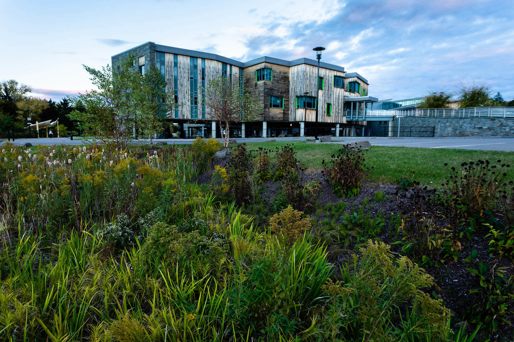
Not far from her office in Binghamton, MacArthur Elementary School was completely destroyed by the 2011 flooding but rebuilt with extensive use of green infrastructure throughout the campus. Rain gardens full of flowers line walkways that use porous pavement, helping soak up more stormwater that could otherwise contribute to flooding. Half the school is essentially on stilts, with a playground below that not only can flood without major damage but allows children a sheltered outdoor space they can use during lighter rains.
Lucas also cited the Two Rivers Greenway, a multiple-use trail between Broome and Tioga counties, as a project that indirectly finds itself at the intersection of flood resilience and livability. One stop on the greenway is Hickories Park in Owego, which Standinger called an excellent use of a floodplain. The park offers green space in the form of campgrounds, open fields and pavilions that can flood without lasting damage.
“Even if it’s not directly a flood mitigation project, I think by coming up with these productive uses for our waterfront areas that are not at terrible flood risk—they can be flooded—I think that just improves our overall resilience,” Lucas said.
In recent years, USC further increased the park’s resilience by planting a forest buffer along Little Nanticoke Creek, which flows past pavilions, camping areas and grassy fields. USC also enlarged a culvert at the park, to allow better passage for storm flows and aquatic wildlife.
Flowing freer, healthier and cheaper
A different culvert project by USC graces a small stream flowing near a dairy barn owned by Chris Luszczek and his family in Tioga County. The older culverts had gotten clogged three times in recent years. The last time was during Tropical Storm Lee, when Luszczek stayed up all night watching the flood waters rise from the driver’s seat of his truck.
“I think climate change was the factor that started us on this journey with these culverts to begin with,” said Mike Jura, USC’s field technician who worked with Luszczek to fund and implement the project. Since then, Jura has also helped the 900-acre farm with erosion issues along nearby Owego Creek.
Rather than simply armoring the creek with heavy stone rip rap, Jura said “we’re looking for more rehabilitative or restorative approaches that are better for both preventing sediment and [improving] the local habitat.” USC installed several in-stream structures to redirect flows away from the stream bank to reduce erosion. They also planted willow shrubs along the water’s edge to add shade and cover.
Besides being more effective overall, the approach has yet another benefit. “This was a much lower cost actually, in this case, than putting in a hard rock bank,” Jura said.
Mike Lovegreen, who works with Jura as the leader of USC’s stream team, said they want more communities to adopt a holistic view of stream health—one that addresses root causes of flooding and that sees streams not as a liability but as a resource.
According to Lovegreen, these projects are changing the culture of how people manage their streams.
“I think we’re starting to understand that we can’t manage...the issues we’re having as a result of climate change just with engineering practices,” Lovegreen said. “We’ve got to do them smarter and we’ve got to do them different than what we did in the past.”
Comments
There are no comments.
Thank you!
Your comment has been received. Before it can be published, the comment will be reviewed by our team to ensure it adheres with our rules of engagement.
Back to recent stories