Chesapeake Bay Program shares latest progress on watershed restoration
Annual update provides recent data for 18 Chesapeake Bay Watershed Agreement outcomes
Today, the Chesapeake Bay Program is pleased to release its annual update on the environmental health and restoration of the Chesapeake Bay watershed. The Bay Barometer is a science-based snapshot of the most recent data that is available for the goals and outcomes of the Chesapeake Bay Watershed Agreement.
This year’s round-up contains the latest information for the 18 outcomes that were updated in 2023. In 2014, the most recent Watershed Agreement was signed, establishing 10 goals and 31 outcomes for the restoration of the Bay, its tributaries and the lands that surround them. Through an extensive network of partners, the Chesapeake Bay Program coordinates data collection and verification to assess the progress of each outcome. Outcomes are updated when new information becomes available, which can occur annually, biennially or in some cases, every 3-5 years.
In 2022, the Chesapeake Executive Council agreed to outline the necessary steps and prioritize the actions needed to meet the targets of the Watershed Agreement outcomes. This process included an assessment of the 31 outcomes to determine if they were on-course or off-course in meeting their goals. This assessment determined that 18 outcomes are on-course, 11 are off-course and two are uncertain pending upcoming data updates. Further information on each of these outcomes, including their successes, challenges and what is needed in order for them to attain their targets, can be found in Charting a Course to 2025: A Report and Recommendations for the Chesapeake Executive Council on How to Best Address and Integrate New Science and Restoration Strategies Leading Up to 2025
“In December, the Chesapeake Bay Program celebrated 40 years of accomplishments resulting from our many partners working together,” said Martha Shimkin, director of the Chesapeake Bay Program with the Environmental Protection Agency. “Our annual Bay Barometer highlights the progress we continue to make as a collaborative partnership. As the new Director for the Chesapeake Bay Program, I’m privileged to lead during this exciting time as we reflect on our successes and challenges and plan for the next chapter in Bay and watershed restoration."
For the 18 outcomes updated in 2023, many show improvement from their previous assessment period. The following highlights are from outcomes that are currently on-course to meeting their restoration targets.
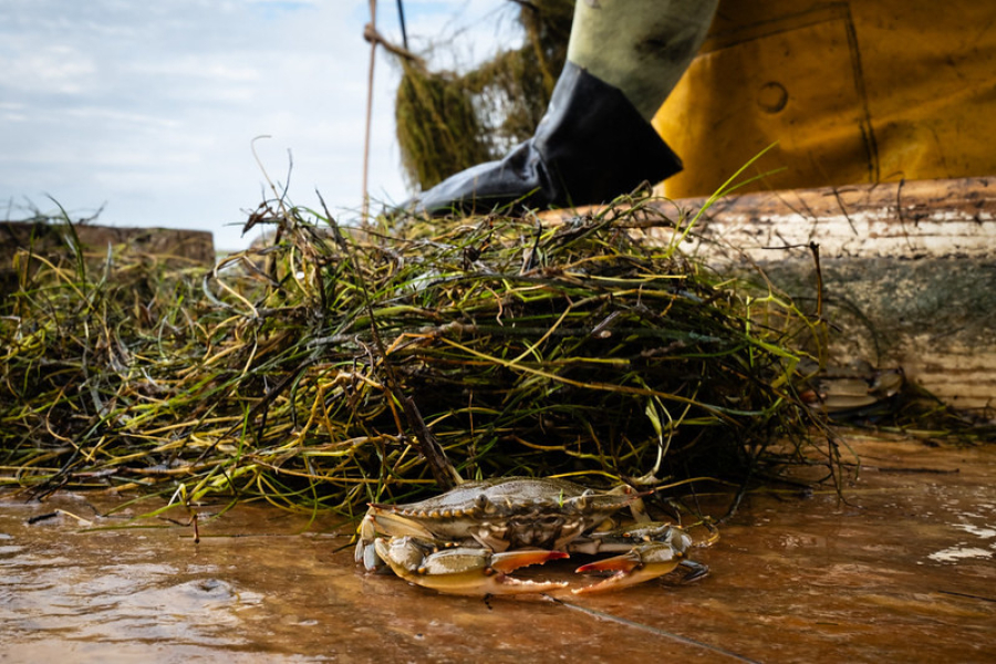
Blue Crab Abundance: The abundance of female blue crabs in the Chesapeake increased 57%, from 97 million in 2022 to 152 million in 2023. This continues to be above the 72.5 million threshold that is considered to be the minimum sustainable level for female blue crabs in the Bay.
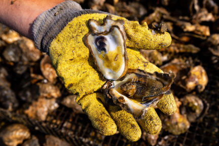
Oysters: Large-scale oyster reef restoration is on track to be completed in 11 tributaries by 2025. Currently, eight sites have been completed with 1,389 acres of oyster reefs constructed at the end of 2022.
Protected Lands: At the end of 2022, 1.64 million acres of land had been permanently protected from development, marking an 82% achievement of the goal to protect an additional two million acres of land in the watershed by 2025. The total amount of protected land in the watershed is now 9.1 million acres.
Public Access: In 2022, 11 new public access sites were added, meeting 83% of the goal to add 300 new public access sites by 2025. This brings the number of public access sites in the watershed to 1,379.
Stream Health: Between 2012 and 2017, 67.8% of stream miles in the watershed were considered healthy, marking a 6% increase since the previous assessment period.
“There is a lot of excitement around the condition of the oyster resources in the Chesapeake Bay these days, " said Andrew Button, deputy chief for the shellfish management division with the Virginia Marine Resources Commission. “Virginia and Maryland are already looking beyond the 2025 oyster restoration goals, wild and aquaculture oyster harvest is at or near a 35 year high, and in Virginia, the oyster populations in almost all areas continues to increase. This points to a resource that is continuing to head in the right direction.”
While the below outcomes are currently considered to be off-course in meeting their restoration targets, each saw promising increases over the past year.
Forest Buffers: Partners planted 230.5 miles of forest buffers in 2021–the most per year since 2016.
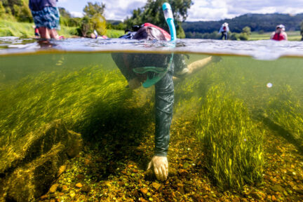
Submerged Aquatic Vegetation (SAV): Acres of underwater grasses in the Bay and its surrounding tributaries increased by 12% from 2021 to 2022, marking the second year of growth since acreage fell dramatically in 2019.
Wetlands: In-between 2014-2022, 4,310 acres of wetlands were created or restored across the Chesapeake Bay watershed. During this same time period an additional 60,666 acres of wetlands were enhanced. This meets 5.1% of the goal to create or restore 85,000 acres of wetlands, and 40.4% of the goal to enhance 150,000 acres of wetlands by 2025.
“As we’ve recommitted to planting streamside trees across Pennsylvania and the watershed with technical assistance and funding, our buffer numbers have been steadily increasing over the past several years,” said Cindy Dunn, secretary of Pennsylvania’s Department of Conservation and Natural Resources. “It’s a reflection of a growing acceptance among landowners of this proven practice, and the work of many partners on the ground to increase capacity to get buffers planted and maintained that positions us for continued progress. Restoring trees along waterways and in communities helps in so many ways.”
Many of the outcomes updated in 2023 provide our partners with the data and information needed to better understand and protect the waters and lands in their backyards. The Chesapeake Bay Program’s Very High-Resolution Land Use/Land Cover and Change Data was used to update the Land Use Methods and Metrics Outcome, which provides data on the miles of impervious surfaces found throughout the watershed. Additionally, it was used to inform the Tree Canopy Outcome, which tracks the net gain and loss of tree canopy across the watershed. Data from these outcomes were used to create individual fact sheets for each county in the watershed to better show how land is being used. Likewise, our Climate Monitoring and Assessment Outcome provides a regional overview of changes in annual precipitation and air temperature due to climate change.
The Chesapeake Bay Program makes this data and information freely available, and it is often used by other organizations for their own report cards, including the Chesapeake Bay Foundation and the University of Maryland Center for Environmental Sciences. As outcome updates become available throughout the year, they can be found on ChesapeakeProgress.com.
A selection of courtesy photos for media organizations is freely available for download.
Recent Press Releases
Annual Chesapeake Bay Awareness Week celebrates a watershed “Built by Nature, Protected Together”
A mild dead zone is expected for the Chesapeake Bay this summer
Chesapeake Bay Program Provides Final Snapshot of Progress Under 2014 Watershed Agreement
Supporting Materials
- 2023 Bay Barometer
- 2023 Bay Barometer: Delaware Fact Sheet
- 2023 Bay Barometer: District of Columbia Fact Sheet
- 2023 Bay Barometer: Maryland Fact Sheet
- 2023 Bay Barometer: New York Fact Sheet
- 2023 Bay Barometer: Pennsylvania Fact Sheet
- 2023 Bay Barometer: Virginia Fact Sheet
- 2023 Bay Barometer: West Virginia Fact Sheet