Maps
Browse through maps depicting Bay health and restoration, including pollution trends, public access sites and more.
Hydrogeomorphic Regions
Date created: February 11, 2008Generalized lithology (rock type) and physiography based on geologic formations were used to characterize hydrgeomorphic regions (HGMR) within the Chesapeake Bay watershed. These HGMRs were used in conjunction with existing data to assess the significance of ground-water discharge as a source of nitrate load to non-tidal streams in the Chesapeake Bay watershed (Bachman and others, 1998). This work is part of the U.S. Geological Survey's (USGS) Chesapeake Bay initiative to develop an understanding and provide scientific information for the restoration of the Chesapeake Bay and its watershed. Bachman J., B. Lindsey, J. Brakebill, and D. Powars. 1998. Ground-Water Discharge and Base-Flow Nitrate Loads of Nontidal Streams, and Their Relation to a Hydrogeomorphic Classification of the Chesapeake Bay Watershed, Middle Atlantic Coast.
View map
Chesapeake Bay Airshed
Date created: February 7, 2008This map depicts the Airshed that is used for Chesapeake Bay modeling purposes. The Airshed Model (Regional Acid Deposition Model - RADM) tracks nitrogen emissions from all sources in the airshed. The model is three-dimensional; it simulates movement both vertically and horizontally across a region. The Airshed Model covers the eastern United States from Texas and North Dakota eastward to Maine and Florida with 22,000 cells. Each cell measures eighty kilometers square. Stacked up, the cells make fifteen vertical layers reaching about fifteen kilometers high. The airborne nutrient loads are transported by the Airshed Model and linked to the Watershed Model through deposition to land surfaces and to the Estuary Model through deposition to the water surfaces of the tidal Bay.
View map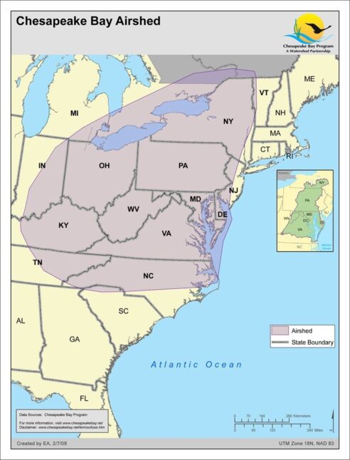
Chesapeake Bay Watershed Physiography
Date created: February 6, 2008Physiographic provinces in the Chesapeake Bay Watershed. Physiographic data derived from USGS and modified by the Chesapeake Bay Program GIS Team to divide the Piedmont into three distinct regions. Two out of the eight major US physiographic regions fall within the Chesapeake Bay Watershed; the Atlantic Plains and Appalachian Highlands. Within these regions, there are eight provinces within the Bay Watershed; the Appalachian Plateau, Appalachian Mountain, Blue Ridge, Great Valley, Mezosoic Lowland, Piedmont Upland, Piedmont Lowland, and Coastal Plains. Physiographic provinces are categorized by rock type, terrain texture, as well as geologic structure and history.
View map
Hydrologic Unit Boundaries - HUC 11
Date created: February 5, 2008The 11 digit Hydrologic Unit Code (HUC) coverage for the Chesapeake Bay watershed states level is an aggregate of the individual states clipped to the Chesapeake Bay Basin boundaries. These states are Delaware, Maryland, New York, Pennsylvania, Virginia, West Virginia, and Washington, D.C. This aggregate HUC-11 data set has been modified by the Chesapeake Bay Program GIS Team from USGS data to ensure edge matching and closed watersheds along state boundaries. There are a total of 506 HUC-11/watersheds for the Chesapeake Bay Basin in this aggregate data set.
View map
Hydrologic Unit Boundaries - HUC 8
Date created: February 5, 20088-digit Hydrologic Unit Code (HUC) for the Chesapeake Bay watershed states level was created by dissolving huc11_hr02.The aggregate HUC-11 data set has been modified from USGS data by the Chesapeake Bay Program GIS Team to ensure edge matching and closed watersheds along state boundaries. There are a total of 506 HUC-11/watersheds for the Chesapeake Bay Basin in this aggregate data set.
View map
Chesapeake Bay Watershed
Date created: January 29, 2008Outline of the Chesapeake Bay watershed with elevation relief.
View map
Chesapeake Bay 2003 Segmentation Scheme - Codes
Date created: January 27, 2008The 2003 Chesapeake Bay Program Segmentation Scheme is a revision of the 2000 version that incorporates four changes: the addition of a new segment (ANATF) that separates the Anacostia River from the rest of the Potomac Tidal Fresh (POTTF) segment, the merger of two Elizabeth River segments (ELIMH and ELIPH into ELIPH) and the small segment boundary location changes between Mattaponi River segments MPNTF and MPNOH and between Choptank River segments CHOTF and CHOOH. Further information about the 2003 Chesapeake Bay Program Segmentation Scheme can be found at http://www.chesapeakebay.net/segmentscheme.htm
View map
Land Cover: Chesapeake Bay Watershed
Date created: January 23, 2008The National Land Cover Database 2001 land cover layer for mapping zone 60 was produced through a cooperative project conducted by the Multi-Resolution Land Characteristics (MRLC) Consortium, a partnership of federal agencies (www.mrlc.gov), consisting of the U.S. Geological Survey (USGS), the National Oceanic and Atmospheric Administration (NOAA), the U.S. Environmental Protection Agency (EPA), the U.S. Department of Agriculture (USDA), the U.S. Forest Service (USFS), the National Park Service (NPS), the U.S. Fish and Wildlife Service (FWS), the Bureau of Land Management (BLM) and the USDA Natural Resources Conservation Service (NRCS). It is intended to serve as a consistent, seamless, and accurate National Land Cover Database circa 2001 for the US at medium spatial resolution. The NLCD 2001 is created by partitioning the U.S. into 66 mapping zones delineated within the conterminous U.S. based on ecoregion and geographical characteristics, edge matching features and the size requirement of Landsat mosaics. The Chesapeake Bay Watershed is derived from zone 60 which encompasses whole or portions of several states, including the states of New York, Delaware, Maryland, Pennsylvania, Virginia, and the District of Columbia. The Chesapeake Bay Program GIS Team modified this data to represent low/medium intensity development, high intensity development, wetlands, forest, agriculture, and barren land within the Chesapeake Bay Watershed.
View map