Maps
Browse through maps depicting Bay health and restoration, including pollution trends, public access sites and more.
Prime Farmland - Resource Lands Assessment
Date created: January 24, 2008Assessing the extent of farming on prime soils in the Bay watershed is a useful measure for determining the lands of highest importance for agricultural productivity and sustainability. This map shows the acres of potential prime soils that are actively farmed per square mile grid cell.
View map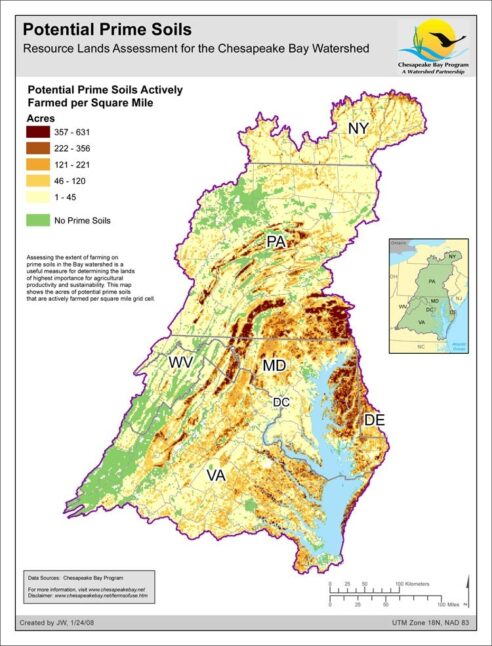
Land Cover: Chesapeake Bay Watershed
Date created: January 23, 2008The National Land Cover Database 2001 land cover layer for mapping zone 60 was produced through a cooperative project conducted by the Multi-Resolution Land Characteristics (MRLC) Consortium, a partnership of federal agencies (www.mrlc.gov), consisting of the U.S. Geological Survey (USGS), the National Oceanic and Atmospheric Administration (NOAA), the U.S. Environmental Protection Agency (EPA), the U.S. Department of Agriculture (USDA), the U.S. Forest Service (USFS), the National Park Service (NPS), the U.S. Fish and Wildlife Service (FWS), the Bureau of Land Management (BLM) and the USDA Natural Resources Conservation Service (NRCS). It is intended to serve as a consistent, seamless, and accurate National Land Cover Database circa 2001 for the US at medium spatial resolution. The NLCD 2001 is created by partitioning the U.S. into 66 mapping zones delineated within the conterminous U.S. based on ecoregion and geographical characteristics, edge matching features and the size requirement of Landsat mosaics. The Chesapeake Bay Watershed is derived from zone 60 which encompasses whole or portions of several states, including the states of New York, Delaware, Maryland, Pennsylvania, Virginia, and the District of Columbia. The Chesapeake Bay Program GIS Team modified this data to represent low/medium intensity development, high intensity development, wetlands, forest, agriculture, and barren land within the Chesapeake Bay Watershed.
View map