Tributary Tuesday: Sideling Hill Creek (Md. and Pa.)
Sideling Hill Creek, a Potomac River tributary that runs through western Md., is one of the healthiest streams in the state.
You may recognize the name “Sideling Hill” from the impressively steep mountainside interrupted by Interstate 68 in western Maryland, about two hours outside of Washington, D.C. If you’re the type that’s impressed by scenery, a westward trip means stopping at the Sideling Hill Rest Stop and Visitors Center to explore the mountainside, which is almost desert-like in its lack of forests.

(Image courtesy dlhdavidlh/Flickr)
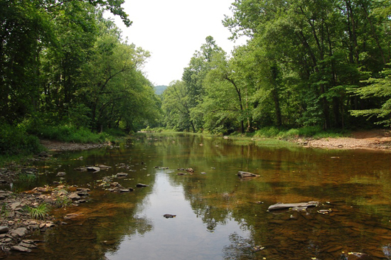
Despite its barren appearance, Sideling Hill Creek, which runs through this mountain, is one of the healthiest streams in the entire state of Maryland. With 287 stream and tributary miles and only 2,200 residents in its watershed, this Potomac River tributary is a fortunate one because it suffers from few human impacts.
Here’s a few ways to explore Sideling Hill Creek:
Look out for rare wildflowers
Sideling Hill is so pristine that it supports an endangered wildflower called harperella (Ptilimnium nodosum). In fact, harperella can only be found in ten places in the world! It’s rumored that this flower also grows in West Virginia along Sleepy Creek and a few Cacapon River tributaries.
Trout, turkey and more
The 3,100 acre Sideling Hill Wildlife Management Area provides opportunities for hunters, anglers and anyone else who enjoys beautiful mountain scenery. In the spring, look out for turkey gobblers as they display their colorful feathers. Old logging roads challenge hikers with a variety of terrains. If you love to canoe or kayak, be sure to visit Sideling Hill in spring to explore one of the Chesapeake Bay watershed’s most scenic local waterways.
Learn about what you’re viewing
With its steep ridges and deep valleys, Sideling Hill is home to unique plants, wildlife and geologic formations. So when you visit, take some time to learn about what you’re looking at! The Nature Conservancy offers a Sideling Hill Creek audio tour that will introduce you to the specific types of rocks and plants found in the area. When your trip is over, you’ll not only be refreshed from the beautiful scenery, but also more knowledgeable about the creek’s link to the greater Bay watershed.
(Image courtesy mdmarkus66/Flickr)
Have you been to Sideling Hill? Tell us how you liked it in the comments!
Comments
You need to go to USGS (the US Geopltical Survey - and access their Bellevue gauge (ca 10 miles downstream from Rte 68) - if it reads 200 cfs or above, you're good to go.
My son and I attempted to canoe the lower stretch of Sideling Hill Creek starting just below Route 68 on Saturday, June 6 2015. We figured that after several days of rain the water level would allow us the to get down to the Potomac. We did more dragging of the canoe than we did paddling so after half-mile we stashed the canoe and walked downstream for a few hundred yards. Conditions did not improve so we turned around and dragged the canoe back upstream.
What we saw looked beautiful but I would suggest checking on the water level before attempting this part.
Could not find a water level gauge on the road bridge.
Thank you!
Your comment has been received. Before it can be published, the comment will be reviewed by our team to ensure it adheres with our rules of engagement.
Back to recent stories