Tier III: SAV Sentinel Site Program
The SAV Sentinel Site Program is a monitoring effort conducted by Bay scientists.
What is the Chesapeake Bay SAV Sentinel Site Program?
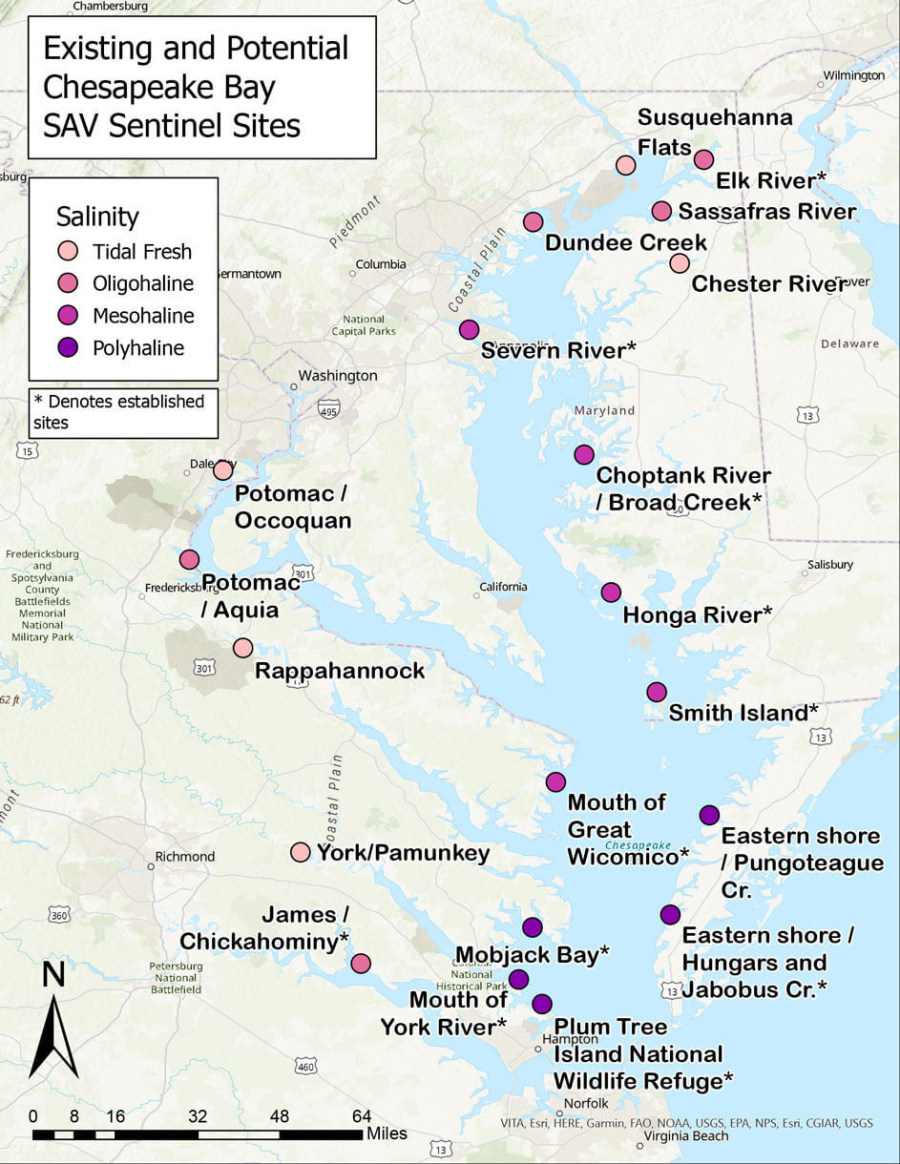
The Chesapeake Bay SAV Sentinel Site Program forms the third tier of the Chesapeake Bay SAV Monitoring effort. SAV sentinel sites are located in each of the Bay’s four salinity zones (tidal fresh, oligohaline, mesohaline and polyhaline) and are monitored using a standardized, in-depth data collection protocol. These sentinel sites are a combination of existing, long-term sites and new sites where Bay scientists monitor changes in SAV habitat characteristics and resilience indicators. This program is coordinated by the Bay Program’s SAV Workgroup. If you are interested in adopting and managing an SAV Sentinel Site, contact the program coordinator, Brooke Landry.
Current SAV Sentinel Sites
The following organizations currently manage one or more SAV sentinel sites during the summer.
- Chesapeake Bay National Estuarine Research Reserve-Maryland
- Chesapeake Bay National Estuarine Research Reserve-Virginia
- Maryland Department of Natural Resources
- St. Mary’s College of Maryland
- Virginia Institute of Marine Science (VIMS)
How do you adopt an SAV sentinel site?
Organizations with dedicated staff, time and equipment for long-term SAV monitoring are invited to adopt an SAV sentinel site. Participation in the Chesapeake Bay SAV Sentinel Site Program is strictly voluntary as no funding is currently available to support this monitoring effort. Interested organizations should refer to the SAV Sentinel Site map to determine where sites are needed and already located. The SAV Workgroup’s goal is to establish five sites in each salinity zone.
SAV Sentinel Site Location Selection and Data Collection Protocol
It takes a certain level of time and equipment to collect data at a sentinel site. Below is a general overview of what’s needed to select and manage a site. For a more detailed review of the data collection protocol or for a copy of the protocol document, contact the program coordinator, Brooke Landry.
Site Selection, Timing and Frequency of Data Collection
Sentinel sites are located based on a number of criteria including ease of access and regional and site-specific data needs. At new or previously established SAV Sentinel Sites, surveys should be conducted three times during the growing season: in early (May-June), mid (July), and late (August-September) summer. Peak biomass varies depending on the salinity regime/SAV community at the SAV Sentinel Site. The following monitoring schedule will ensure that a survey takes place during emergence, peak biomass, and senescence of each of the Bay's SAV communities.
Equipment Needed for Data Collection
- Chesapeake Bay SAV Sentinel Site Monitoring Program data sheet and protocol document
- Pencil
- GPS-enabled device
- Watch
- Secchi disc
- Camera
- Refractometer or probe
Protocol for Tier 3
Data Collection
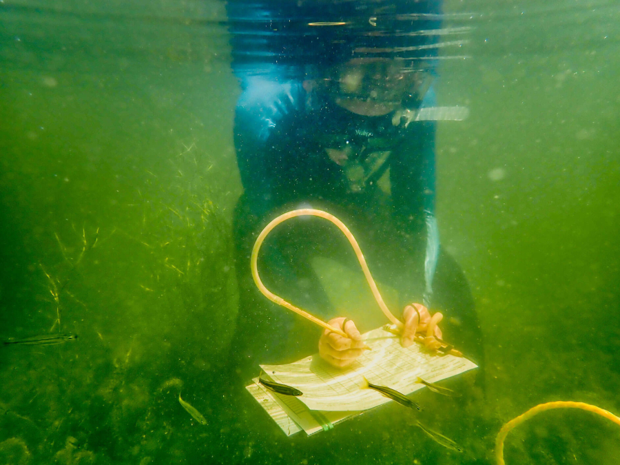
The following four steps are needed to complete a basic protocol data collection.
- Run Transects and determine quadrat spacing depending on transect length.
- At each transect, measure and record general site parameters on the data sheet and take pictures. General site parameters include things like coordinates, salinity and Secchi depth.
- At each survey point along the transect, measure and record physical and water quality parameters on the data sheet. Physical and water quality parameters include things like water depth and sediment type.
- At each survey point along the transect, measure and record biological parameters within a 0.25m2 quadrat on the data sheet. Biological parameters include things like SAV species cover, canopy height, and epiphyte loading.
Data Submission
Monitoring partners will be provided all necessary protocols, datasheets, and access to the Chesapeake Bay SAV Sentinel Site Google drive folder. Once sites are surveyed, all data files should be copied to the Google drive folder for reporting. To become a monitoring partner or site adopter, contact the program coordinator, Brooke Landry.
Resources for comprehensive SAV monitoring
Comparing sentinel site data to other ecosystem conditions, such as water quality, flow conditions, climate and weather can add depth, relevance and insight to SAV monitoring and research. Some useful sites for obtaining data are listed below for your convenience.
Water Quality and Flow Condition
- Conowingo Dam Flow
- Maryland Eyes on the Bay
- USGS Current National Water Data
- USGS National Water Dashboard
- Virginia Estuarine and Coastal Observing System (VECOS)