Historic number of trees planted in Bay watershed communities in 2024
Despite increase, overall tree canopy declines across the Chesapeake region
Annapolis, Maryland — New data released today by the Chesapeake Bay Program shows both gains and setbacks in efforts to plant and conserve trees across the Bay watershed. In 2024, the partnership reported its most successful year to date for planting community trees, which refers to those trees planted across cities, suburbs and other residential areas. However, miles of streamside buffers planted decreased, and updated data shows an overall net loss in both tree canopy and streamside buffers.
Community Tree Plantings
In 2024, the Bay jurisdictions–Delaware, the District of Columbia, Maryland, New York, Pennsylvania, Virginia and West Virginia–planted 5,743 acres of community trees in their portion of the watershed, more than double the acres planted in 2023 and the highest total reported since tracking began in 2014. This surge reflects increased investments by state and local governments in urban forestry programs.
Since 2014, approximately 17,082 acres of trees have been planted in communities across the watershed. The largest contributions came from Maryland (10,357 acres), Pennsylvania (5,041 acres) and Virginia (1,046 acres), followed by the District of Columbia (449 acres), New York (112 acres), West Virginia (45 acres) and Delaware (32 acres).
“It is remarkable to see how federal, state and local investments in urban and community forestry have paid off in the Chesapeake Bay watershed with these record-breaking planting rates," said Katherine Brownson, liaison for the U.S. Forest Service to the Chesapeake Bay Program and coordinator of the Forestry Workgroup. “These trees will be critical to provide clean water, shade, air and recreational opportunities for local communities throughout the watershed.”
However, despite this progress, the updated High-Resolution Land Use/Land Cover Data released in June 2025, shows a net loss of more than 28,000 acres of tree canopy in the watershed between 2013-2014 and 2021-2022. With these losses, the Chesapeake Bay Program will not meet its 2014 Chesapeake Bay Watershed Agreement Tree Canopy Outcome to expand urban tree canopy by 2,400 acres by 2025.
To help decision makers understand their canopy and conserve trees, the Chesapeake Bay Program’s Forestry Workgroup, in partnership with the U.S. Forest Service and the Chesapeake Conservancy, used the the most recent High-Resolution Land Use/Land Cover Data to update the county-level Tree Cover Status and Change Fact Sheets and develop new fact sheets for the municipality level. The fact sheets break down how the land is used in each municipality and county, including the net gain or loss of trees. It also estimates the value of benefits that trees provide in each area.
“In April 2024, the Metropolitan Washington Council of Governments (COG) passed a 2050 tree canopy goal of 50% regionally,” said Mike Knapp, former chair of COG’s regional tree canopy subcommittee. “The Chesapeake Bay Program’s land use/land cover data and tree canopy fact sheets were instrumental in setting our overall tree canopy goal, as well as targets. The new 2021-22 land use/land cover data will be used to assess trends in tree canopy gains and losses, and to revisit projections for the COG region.”
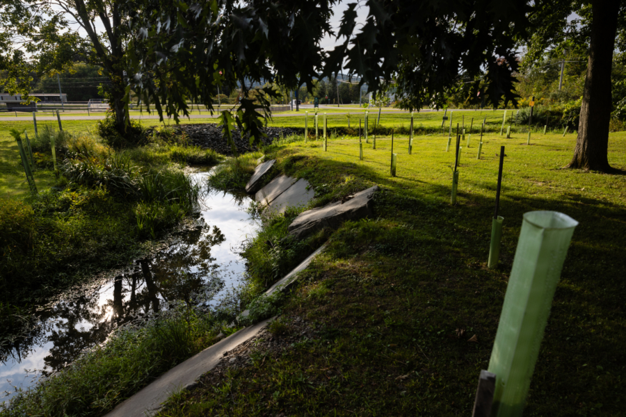
Streamside Buffers
In contrast with tree canopy, the miles of newly planted streamside buffers saw a downturn in 2024. Only 227 miles of streamside buffers were planted, representing 25.2% of the annual Forest Buffers Outcome target of 900 miles. This marks a decline after several years of increased plantings that came in response to a surge of investments and reporting in 2022 and 2023. By far the largest contribution of forest buffers in 2024 came from Pennsylvania (111 miles), followed by Virginia (43), New York (34), Maryland (25), West Virginia (13) and Delaware (less than 1 mile).
“The Pennsylvania Department of Conservation and Natural Resources (DCNR) is very pleased and proud to see the progress with tree planting and riparian forest buffers in Pennsylvania,” said Assistant Director Matt Keefer of Stewardship, Protection and Conservation at DCNR. “As we geared up during the Phase 3 WIP planning process, we emphasized the importance of developing programs that work for landowners, municipalities and with many different partners. Thank you to all the partners working on the ground to make the connections with landowners and farmers who have chosen to plant trees and riparian forest buffers. These investments in land and stewardship are important not only for water quality but also enhancing habitat and improving communities throughout Pennsylvania.”
The Forest Buffers Outcome also aims to conserve existing streamside buffers until at least 70% of riparian areas in the watershed are forested. While some jurisdictions—such as Pennsylvania, Virginia and West Virginia—have achieved more than 70% streamside buffer coverage, the watershed as a whole remains just shy of the 70% target, at 69.96% of riparian areas covered, according to the 2021-2022 High Resolution Land Use/Land Cover Data. However, since 2013-14, the region has experienced a net loss of 41,941 acres of riparian forest, with only the District of Columbia showing a net gain (three acres).
“We appreciate the broad support for maintaining clear goals for riparian forest buffers and urban tree canopy,” said Anne Hairston-Strang, state forester, director of the Maryland Forest Service and chair of the Chesapeake Bay Program Forestry Workgroup. “Combining and bolstering these essential elements with broader forest conservation efforts will be a real plus for durable progress. Achieving these goals will be a stretch, beyond existing rates even with the new tree planting initiatives in many states, but retaining incentive for increasing progress underscores the fundamental need for these nature-based solutions.”
| Jurisdiction | Riparian Land Area (in acres) | Forest Cover Acres 2021-22 | Forest Cover % 2021-22 | Forest Cover Acres 2013-14 | Forest Cover % 2013-14 | Net Change in Acres | Net Change in % |
| Delaware | 55,140 | 30,991 | 56.21% | 31,328 | 56.82% | -337 | -0.61% |
| District of Columbia | 1,737 | 1,011 | 58.18% | 1,008 | 58.05% | + 3 | +0.13% |
| Maryland | 689,035 | 423,965 | 61.53% | 425,794 | 61.8% | -1,828 | -0.27% |
| New York | 331,662 | 210,985 | 63.62% | 213,976 | 64.52% | -2991 | -0.9% |
| Pennsylvania | 1,422,902 | 998,004 | 70,14% | 1,005,420 | 70,66% | -7.416 | -0.52% |
| Virginia | 1,879,844 | 1,384,394 | 73.64% | 1,411,746 | 75.1% | -27.353 | -1.46% |
| West Virginia | 269,915 | 204,034 | 75.59% | 206,052 | 76.34% | -2,018 | -0.75% |
| Total Watershed | 4,650,195 | 3,253,384 | 69.96% | 3,295,325 | 70.86% | -41,941 | -0.9% |
The above table shows a net loss of forest in the riparian area for every Chesapeake Bay watershed jurisdiction except the District of Columbia between 2013-14 and 2021-22.
The Benefits of Forests and Trees to the Chesapeake Bay Watershed
Planting trees is one of the most cost-effective practices for reducing nitrogen, phosphorus and sediment runoff from entering the Chesapeake Bay and local waterways. Collectively, trees also provide major economic benefits.
According to new estimates in the Bay Program’s 2025 update of the State of Chesapeake Forests Storymap, trees in the watershed provide over $15.3 billion in benefits annually by lessening air pollution, reducing stormwater runoff and sequestering carbon. The Storymap is a follow-up to the original 2006 State of Chesapeake Forests report. The Storymap provides a watershed-wide summary of the Chesapeake Bay Program’s latest High-Resolution Land Use/Land Cover Data for the watershed’s forests and trees to support conservation and restoration throughout the watershed.
Recent Press Releases
Annual Chesapeake Bay Awareness Week celebrates a watershed “Built by Nature, Protected Together”

A mild dead zone is expected for the Chesapeake Bay this summer
Chesapeake Bay Program Provides Final Snapshot of Progress Under 2014 Watershed Agreement