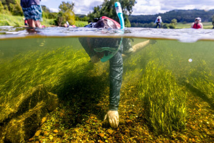
Underwater Grasses Survey Shows Both Decline and Resilience in 2011
Underwater Grasses Survey Shows Both Decline and Resilience in 2011
In 2011, the abundance of underwater grasses in the Chesapeake Bay and its tidal rivers declined by 16,590 acres from 2010 figures according to Chesapeake Bay Program (CBP) scientists in Maryland and Virginia. Grass beds declined from 79,664 acres in 2010 to an estimated 63,074 acres in 2011. This is the lowest Bay-wide acreage since 2006 and is much more typical of what was observed prior to 1991 when grass acreages were at the lowest levels recorded by the aerial survey. Only 57,956 acres were mapped Bay-wide in 2011 and an estimated 5,119 additional acres may have been present (for an estimated Bay-wide total of 63,074).
Experts agree that extreme environmental conditions in both 2010 and 2011 contributed strongly to the decline last year. “2011 was an especially challenging year for SAV in the Bay,” says Bob Orth of the Virginia Institute of Marine Science (VIMS) and coordinator of the annual Bay-wide survey.
“The summer of 2010 was unusually hot, causing eelgrass beds in the lower bay to severely die back after they had been surveyed earlier in the year,” Orth continues. “Then in spring of 2011, during the growth season, heavy rains and freshwater runoff created very muddy conditions for many low salinity species, in the upper Bay and tributaries. This was followed in September and October by Hurricane Irene and Tropical Storm Lee that again muddied the water.”
According to Lee Karrh, chair of the Submerged Aquatic Vegetation (SAV) Workgroup, “2011 was the year that bucked two trends we’ve seen over the last decade. The Upper Bay had major decreases after years of increasing or sustained high acreages. On the other hand, the brackish parts of the Middle Bay witnessed dramatic increases in 2011, after prolonged decreases since the turn of the century.”
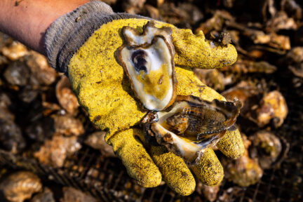
Despite Bay-wide losses, there was some good and surprising news for underwater grasses last year, too. Researchers were pleased to find that a huge, dense bed on the Susquehanna Flats, which had increased 3-fold in size since 1991 and passed restorations goals in 2008 through 2010, persisted through the storms and demonstrated how resilient such grass beds can be to water quality disturbances. Additionally, due to a growth of widgeon grass (which fluctuates annually), grass acreages increased over 1,200 acres in Eastern Bay, 2,400 acres in the Choptank River and over 300 acres each in the Little Choptank and Honga Rivers. Steve Ailstock, who works with freshwater and brackish species at Anne Arundel Community College, explains, “The lower salinities associated with rain events can stimulate the germination of the dormant seeds of many mid-Bay species like those of widgeon grass, redhead grass and horned pondweed that are buried in the sediments.” In a final bright spot, the survey recorded the first bed of freshwater SAV in the James River mainstem since the area was first surveyed 1998.
Underwater Bay grasses are critical to the Bay ecosystem. They provide habitat and nursery grounds for fish and blue crabs, serve as food for animals such as turtles and waterfowl, clear the water by reducing wave action, absorb excess nutrients and reduce shoreline erosion. They are also an excellent measure of the Bay's overall condition because their health is closely linked to water quality. Annual acreage of grasses is estimated through an aerial survey, which is flown from late spring to early fall.
Annual underwater grass acreage estimates are an indication of the Bay's response to pollution control efforts, such as implementation of agricultural best management practices (BMPs) and upgrades to wastewater treatment plants. Homeowners throughout the Bay region help bay grasses and overall water quality by using landscaping techniques that keep excess nutrients from flowing downstream where they can harm nearby streams and eventually the Bay. Local watershed groups and online resources such as CBP’s “Plant More Plants” campaign can offer people more information.
Karrh says, “Our hope is that the implementation of the Bay ‘pollution diet’ will help increase SAV acreages in areas that currently are below our restoration goals and reduce the impacts of extreme weather events in the future.”
Grass Numbers by the Zones
Upper Bay: In the Upper Bay Zone (from the Chesapeake Bay Bridge north), underwater grasses covered about 13,287 acres, down from 21,353 acres in 2010. This is most likely an underestimate of the total area of grasses in the northern most part of the Bay, since they were photographed in November when poor water clarity finally improved, but well past the time when plants would have been at their maximum extent. One positive increase was the more than doubling of SAV in the Eastern Neck Narrows and Chester River. This again may have been due to lower salinity conditions for freshwater species in the region following the spring freshet.
Mid-Bay: In the Middle Bay Zone (from the Chesapeake Bay Bridge to the Potomac River and Pocomoke Sound), underwater grass acreage decreased 4 percent to an estimated 34,142 acres, down from 35,446 acres in 2010. Large losses occurred in the Tangier Sound region where eelgrass is dominant and had declined the previous summer after that survey was completed. The losses were offset by the large gains in widgeon grass in many upper middle bay segments, such as Eastern Bay, Choptank and Little Choptank. Only 29,023 acres were mapped in the middle Bay in 2011. It is estimated that an additional 5,119 acres may have been present (for an estimated total of 34,142). .
Lower Bay: In the Lower Bay Zone (south of the Potomac River), researchers found 15,645 acres of underwater grasses – down 32% from 22,685 acres in 2010. This decline occurred primarily in the higher salinity areas due to the hot summer of 2010, and reversed the gains that followed in 2011. These areas had been recovering from similar losses in the 2005 summer heat event. Freshwater grasses have remained at consistently high levels in the tributaries with new beds appearing in several areas of the mainstem James River.
Recent Press Releases
Annual Chesapeake Bay Awareness Week celebrates a watershed “Built by Nature, Protected Together”
A mild dead zone is expected for the Chesapeake Bay this summer
Chesapeake Bay Program Provides Final Snapshot of Progress Under 2014 Watershed Agreement