Phase 7 Model Development
In ProgressThese updated modeling tools will be used by the Chesapeake Bay Program partnership to inform decisions related to the nutrient and sediment reduction goals outlined in the revised Watershed Agreement.
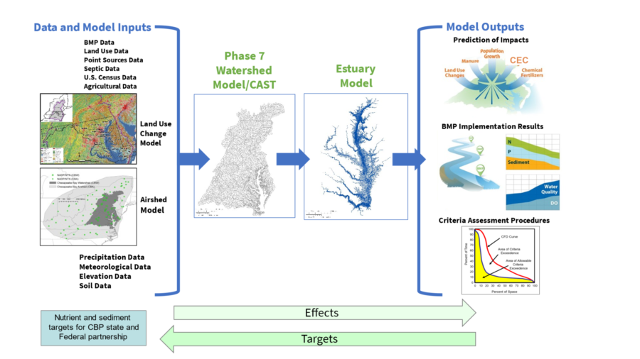
Description
Currently in development, the Phase 7 Model project is focused on updating the tools for the Chesapeake Bay TMDL relating nitrogen, phosphorus, and sediment reductions to improvements in tidal dissolved oxygen, clarity, and chlorophyll. Integral to this updated suite of tools is the ability to project changing environmental conditions through 2035. The model, which will be ready for use by 2028, consists of eight interrelated projects:
- High Resolution Land Use
- Chesapeake Assessment Scenario Tool (CAST)
- Optimization
- Agricultural Inputs
- Atmospheric Deposition Modeling
- Watershed Modeling
- Estuarine Modeling
- Criteria Assessment.
How are these projects interrelated? - CAST is a publicly available model of the Chesapeake Bay watershed used to estimate changes in long-term nutrient and sediment loads due to changes in point sources, land use and land management. Watershed modeling provides the science behind the calculations in CAST while optimization allows users to find a least cost management option in CAST for a given nutrient and sediment reduction. The production of new high resolution land use data and the improvement of agricultural inputs will inform and improve the phase 7 watershed modeling products while also providing important data for other CBP goals and outcomes. Estuarine Modeling translates changes in nutrients and sediment to water quality outcomes in the tidal waters of the Bay. Criteria Assessment is the process of determining whether the predicted water quality outcomes meet state water quality standards.
The development of the Phase 7 model is ongoing. Evolving plans and related documents will be posted here as they become available. More information on the role of the model in the Chesapeake Bay Program, and why this update is happening can be found on the Modeling Page.
Resources
Partnership Planning Documents
- Phase 7 Timeline Extension (Presentation: Aug 2025, PSC) - An extension to the timeline of Phase 7 Development was approved by the PSC at their Aug 2025 meeting, setting the delivery date of the model suite for partnership review to January 1, 2027. A more detailed presentation of the extended timeline is available here.
- Scoping for Year of Review (Presentation: Jul 2025, MWG) - Outline of potential plan and priorities for the Year of Review by the partnership and STAC.
- Chesapeake Bay Modeling Segmentation Viewer - Interactive segmentation viewer of the airshed, watershed, and estuarine models, monitoring stations, and other layers.
- Planning Target Development Presentations (Presentations: Jan 2026, WQGIT) - Initial briefs on planning targets, E3/no-action scenarios, and tiered implementation to aid future discussions for how these will work in Phase 7.
- Review of the Phase III WIP Planning Targets Method (Recording: May 2026, WQGIT) - Overview of how the needed load reductions to meet water quality standards were determined and how those loads were distributed across jurisdictions previously.
WQGIT Inputs and Methods Review
- Phase 7 WQGIT Decision Planners (Jul - Sep 2025 and Oct 2025 - Feb 2026) - Charts to track the progress of Phase 7 input decisions in the WQGIT and relevant workgroups. These are final versions for these time periods and serve as a log of decisions.
- Phase 7 WQGIT Office Hours (Recordings: Aug-Sep 2025, WQGIT) - These sessions aimed to facilitate comprehension of Phase 7 topics and updates for the WQGIT or other interested parties. Notes from all three sessions are compiled here. Recordings from the sessions can be viewed at the following links: BMP Excess and Land Use Loading Rate Ratios, Land Use Topics, and Wastewater Topics.
- Phase 7 WQGT Decision Descriptions (Jul 2025) - List of Phase 7 input decisions being decided on by the WQGIT or relevant workgroups from Jul 2025 - Feb 2026.
Foundational Planning Documents
- Phase 7 Tracks Updates (Presentation: Apr 2023, WQGIT) - Various updates from track leads on progress for the Phase 7 model.
- Phase 7 Draft Documentation Section 1: Overview (Dec 2022) - An initial draft of the Overview and Modeling Strategy section of the Phase 7 Model documentation, including the purpose and main model structure.
- Phase 7 Tracks (Presentation: Apr 2022, WQGIT) - Outline of the eight development tracks and their schedule documents.
- Phase 7 Activities and Priorities (Jan 2022, WQGIT) - Revised priorities for Phase 7 model development prepared for the WQGIT to provide feedback.
- Watershed Modeling Workplan Options (Oct 2021, WQGIT) - Layout of options for prioritization in the development and application of the Phase 7 suite of modeling tools and the CBPO watershed modeling team’s planned development time.
- Chesapeake Regional Hydrologic Model Plan (Oct 2019) - Discussion of the need for hydrologic predictions that effect environmental endpoints and the resources available to produce the predictions.
High Resolution Land Use
Contact - Peter Claggett and Sarah McDonald | Land Use Workgroup
High resolution land use products are developed at the meter scale for Phase 7. These will go directly into the watershed modeling efforts and provide information for other CBP partnership goals and outcomes. Changes to the classification schema for Phase 7 include redistribution of classes under mixed open and the addition of two solar classes, a construction class, and a harvested forest class.
- Phase 7 Land Use Aggregation (Sep 2025, WQGIT) - Outline of how different land use products relate to each other and changes to the aggregation of High-Resolution Land Use/Land Cover to Phase 7 Land Uses.
- High-Res Land Use/Land Cover Data Update (Jun 2025) - New Land Use/Land Cover dataset representing 2021/2022, updates the 2013/2014 and 2017/2018 High-Resolution Land Use/Land Cover Data and Change Data. A web viewer is available here.
- Hyper-Resolution Hydrology Database (Jun 2025) - Dataset identifying the location, dimensions, and connectivity of streams, ditches, and other waterways. A web viewer is available here.
- Chesapeake Bay Watershed Historical Land Use (1985-2013) Workplan (Jun 2025) - Methodology for developing the back-cast land use for 1985 through 2012 where there is less detailed land cover/use data than the 1-meter scale data available for 2013, 2017 and 2021.
- Geospatial Support Activities Timeline (Sep 2024, LUWG) - Gantt chart outlining the planned timeline for Phase 7 land use work for 2024-2025.
Chesapeake Assessment Scenario Tool (CAST)
Contact - Jess Rigelman and Auston Smith | Water Quality GIT and Watershed Technical Workgroup
CAST is a publicly available model of the Chesapeake Bay watershed used to estimate changes in long-term nutrient and sediment loads due to changes in point sources, land use and land management. CAST will receive upgrades to improve transparency and usability as part of a project that will also redesign the process for submitting management practice data. A spatial interface to CAST will be designed to give output for a user-defined spatial extent.
- Phase 7 Land Use/CAST Load Sources Crosswalk Table (Sep 2025) - Aggregation of High-Resolution Land Uses to Phase 7 Mapped Land Uses and the corresponding Phase 7 CAST Load Sources. It also includes loading rate ratios for each load source.
- Phase 7 CAST Load Sources (Presentation: Sep 2025, WQGIT) - Outline of the Phase 7 CAST Load Sources by Agriculture, Developed, and Natural sectors, highlighting any new land uses and changes from Phase 6.
- CAST Updates Timeline (Presentation: Feb 2024) - Gantt chart and outline of planned activities for Phase 7 CAST work.
Optimization
Contact - Lew Linker | Modeling Workgroup
Optimization software is being developed so that CAST scenarios can be generated representing the least cost to achieve a desired level of nutrient and sediment reduction.
- Optimization Project Updates (Presentation: Oct 2025, MWG) - Timeline of the project and close-out steps.
- Optimization Project Updates (Presentation: Jan 2024, MWG) - Outline of work for Task 3 of the project.
- Optimization Planning Spreadsheet (Jan 2022) - Outline of the original timeline for the project.
Agricultural Inputs
Contact - Tom Butler | Agricultural Modeling Team
The Agricultural Modeling Team (AMT) was created to examine and revise the agricultural inputs to CAST. The goal is to achieve a realistic representation of the nutrients from manure, commercial fertilizer, fixation, crop uptake, soil storages, and other agricultural inputs over time.
- AMT Workplan 2023-2025 (Updated Apr 2025) - Roadmap outlining the topics which the group will cover in addition to the anticipated timeline for evaluation of these topics.
- Path Towards the Finish (Presentation: Jun 2025, AMT) - Outline of remaining items for the AMT, including inorganic fertilizer, broilers, and animal population layers.
- Crop Yields, Land Uses, and Sensitivities Update (Presentation: Jan 2024, AMT)
Atmospheric Deposition Modeling
Contact - Lew Linker | Modeling Workgroup
The CBP is using the EPA's Community Multiscale Air Quality Model (CMAQ) model to track atmospheric deposition of nitrogen. The latest version of the CMAQ model will be used as input loading to the watershed model. A source apportionment model (CMAQ-ISAM) will be used to estimate changes due to proposed emission reductions beyond State Implementation Plans.
- Overview of Refinements in Phase 7 (Presentation: Feb 2026, WQGIT) - Airshed Model improvements and changes outlined on slides 58-60.
- Phase 7 Atmospheric Nitrogen Deposition Loads (Presentation: Jul 2025, MWG) - Methods for merging Phase 6, CMAQ and GCAM loads and estimated Phase 7 atmospheric nitrogen deposition input loads.
- Integrated Source Apportionment Analysis of Atmospheric N-Deposition (Presentation: Oct 2023, MWG) - Estimated Phase 6 inputs and delivery of nitrogen to the Bay watershed and delivery coefficients for the Region - Source scale.
- Atmospheric Deposition Modeling in the Chesapeake Bay Watershed (Presentation: Apr 2022, MWG) - Trends in atmospheric deposition and the role of using ISAM to model source apportionment to the watershed.
Watershed Modeling
Contact - Lew Linker | Modeling Workgroup
The watershed model underlying the CAST calculations is being updated for better representation of physical processes, improved nutrient application calculations, and variable-scale modeling.
- Overview of Refinements in Phase 7 (Presentation: Feb 2026, WQGIT) - Outline of main improvements and changes to the watershed model from Phase 6.
- Dynamic Watershed Model Development Update (Presentation: Oct 2025, MWG) - Progress on the NHD Scale Dynamic Watershed Model and linkage of it to the Main Bay Model.
- Watershed Model Development Tracks and Timeline (Presentation: Jun 2023, MWG) - Outline of the Phase 7 development timeline and tasks through 2026 and maps on 2055 climate adjustment.
- Watershed Model Development Process (Poster: May 2022) - Flowchart graphic outlining the watershed model development process.
- Watershed Model Task List (Apr 2022)- Outline of tasks as part of the watershed model development.
Estuarine Modeling
Contact - Lew Linker | Modeling Workgroup
A new estuarine model is being developed for the entire tidal Chesapeake (the Main Bay Model or MBM) incorporating the latest techniques. Multiple Tributary Models (MTMs) are also being developed as testbeds for improved overall model performance.
- Overview of Refinements in Phase 7 (Presentation: Mar 2026, WQGIT) - Main Bay Model and Multiple Tributary Model improvements and refinements.
- MBM Task List, Jan 2022 (Jan 2022)- This spreadsheet outlines tasks and timelines for development of the Phase 7 MBM.
- Main Bay Model Update (Presentation: Jul 2025, MWG) - Progress on updated workflow, the latest MBM modeling results, and assessment of sediment diagenesis and living resource modules.
- Main Bay Model Update (Presentation: Jan 2024, MWG) - Progress on improvements to DO simulation, added shoreline erosion and atmospheric deposition loadings, updated workflow, and remaining issues.
- Potomac and James Rivers MTMs Update (Presentation: Jan 2024, MWG) - Progress on the Potomac and James River MTMs and impacts of benthic algae and phosphorus limitations.
Criteria Assessment
Contact - Peter Tango | Bay Oxygen Research Group and Hypoxia Collaborative Team
The estuarine water quality criteria assessment procedures are being considered for revision based on changing environmental conditions. A separate effort looks to create a new Bay interpolator using vertical profiler data to generate DO estimates across space and through time, improving upon the current spatial interpolation used in the Chesapeake Bay. The output of the tool will allow for expanded evaluation of short-duration criteria and aid in habitat assessments.
- Water Quality Criteria 101 and 4-D Interpolator Overview (Presentation: Mar 2026, WQGIT) - Primer on Chesapeake Bay water quality criteria, reference curves, the bio-reference curve, and the 4-D interpolator.
- 4-D Assessment Tool and Criteria Assessment Monitoring Advances (Presentation: Apr 2023, WQGIT) - Outline of the value, progress and plan for the 4-D interpolator tool and other monitoring advances.
- 4-D Interpolator Overview (Mar 2022) - Outline of a new interpolation and attainment assessment system built on an expanded data collection effort to aid in the assessment of all water quality criteria.